As fall settles in across the Southern Tier, many in southwestern New York are already wondering: will this winter bring deep snow or another stretch of mild, slushy weather?
The National Oceanic and Atmospheric Administration (NOAA) recently released its 2025–2026 winter outlook, offering early hints about what’s ahead.
While the data gives us some clues, experts remind everyone not to take it as gospel.
A Warmer-Than-Normal Winter Looks Likely
NOAA’s temperature outlook shows warmer-than-average conditions expected across most of the Northeast — including New York State.
The only parts of the U.S. expected to lean colder are in Washington and northern Oregon.
For southwestern New York, that means fewer prolonged cold snaps and more days hovering near the freezing mark — a recipe for mixed precipitation, not deep freezes.
“Warm” doesn’t mean any less snow, however. The Great Lakes’ influence can easily flip the switch, especially when cold air briefly rushes across Lake Erie.
Those short but sharp lake-effect events can still drop a quick foot or more of snow in areas like Jamestown, Chautauqua, and Olean.
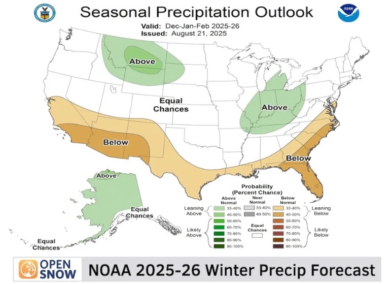
Slightly Wetter Pattern Possible Near Lake Erie
While much of New York should see near-normal precipitation, NOAA notes that a small pocket of western New York near the Pennsylvania border could see increased rain and snowfall.
That puts the Chautauqua Ridge and Southern Tier snowbelt in line for a bit more action than average, especially if lake-effect bands set up in the right direction.
For residents here, it could mean a winter that feels “typical” overall, but punctuated by a few intense snow events.
Watching La Niña’s Role
Another wildcard is La Niña, the periodic cooling of Pacific Ocean waters that can alter storm tracks across North America.
Right now, NOAA gives a 45% chance of La Niña and a 48% chance of neutral conditions — meaning this winter could lean weakly into a La Niña setup.
Historically, a weak La Niña tends to bring more snow to Syracuse and western New York compared to moderate or strong ones.
If that pattern holds, the Southern Tier might see a few well-timed bursts of snow mixed into an otherwise mild season.
What This Means for You
For residents of Chautauqua, Cattaraugus, and Allegany counties, here’s the big picture:
- Expect temperatures a bit above normal, with occasional cold snaps.
- Lake-effect snow could still pack a punch — especially downwind of Lake Erie.
- Storm frequency might be average, but each one could bring more rain-snow mixes than deep Arctic blasts.
In short: don’t count on a record-breaking winter, but keep the snowblower tuned up anyway. The Southern Tier’s weather rarely stays quiet for long.
Subscribe to the Hello Southern Tier newsletter to get the latest local news, events, and updates delivered to your email inbox weekly!